Colonial Road
This rocky pathway is a surviving section of roadway dating back to the colonial era. Like many roads in New York colony, it is nearly certain that enslaved people worked to construct and maintain it. The colonial government did not have its own road construction crew. Instead, local people were required to provide the labor to build and maintain roads. Wealthy merchants like the Van Cortlandts would not have wielded the pick and shovel to do this work themselves. Instead, the enslaved workforce of Van Cortlandt plantation were forced to provide the labor.
The physical demands and long days of repetitious manual labor took its toll on the bodies of enslaved people. Excavations at the African Burial Ground in lower Manhattan revealed the skeletons of enslaved Africans exhibited physical deformities as a result of this work. Andrew Saxton, an enslaved African cooper held by the Van Cortlandts, was described as having several physical ailments in a 1733 “run-away ad” that was posted in a newspaper by Jacobus Van Cortlandt. The ad mentioned that he ”walks stooping” and “somewhat lamish” while his thumb was “stiff” from “a wound he had in his hand.”
Historically, this roadway continued north across the Parade Ground to the base of Vault Hill, where it forked with one path leading north to the Albany Post Road and another leading northeast along Tibbetts Brook. That northeastern branch largely follows the course of today’s Saw Mill River Parkway as it approaches Central Yonkers.
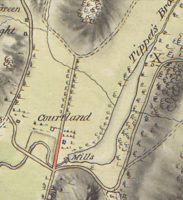
Historical map of colonial road (highlighted in red).
Several important roads traversed Van Cortlandt Park in the colonial period. At the southern end of this old roadway, it connects with trails heading in different directions. Historically, this spot was an important intersection of well-used roads. The strategically important Albany Post Road approached this intersection from the south and it continued west to the high ground of Riverdale before continuing north. Another road, commonly called the “road to Mile Square,” continued from this intersection to the east. It hugged the southern end of Van Cortlandt Lake and continued northeast through Yonkers to the colonial settlement of Mile Square, where today the Cross County Shopping Center is located.
During the American Revolution, the Mile Square Road was frequently patrolled by British soldiers that were stationed in Kingsbridge to prevent a surprise attack by the Continental Army. Sections of the road to Mile Square still exist. One section of the old road is today called Van Cortlandt Park East and sections in Yonkers are still called the Mile Square Road. Many roads that date back to the colonial period have an earlier history as trails used by the native Lenape people.
Road construction was just one of the ways that enslaved people contributed to the development and growth of New York from the colonial period and onward. These road segments are part of their lasting legacy in our area.